Explore Tennessee Route 385 from Millington to Arlington with this 17-mile drive through suburban Shelby County. Follow this high-speed corridor past Millington’s Navy base, rolling hills, and the eastern edge of Memphis.


State highways form the backbone of regional travel across the United States, offering essential connections between cities, rural communities, and major national routes. Managed by individual state departments of transportation, these highways vary widely in scale—from narrow rural byways to multi-lane expressways rivaling interstates in traffic and speed. While numbering systems and signage conventions differ from state to state, each network plays a critical role in local mobility and economic development.
Unlike the federally designated Interstate and U.S. Highway systems, state highways are developed and maintained at the state level, giving them a unique character and flexibility. Some follow historic paths and scenic corridors, while others serve as modern commuter routes or urban spurs. Many are vital links to state parks, natural attractions, and lesser-known destinations that don't fall within the national systems.
On this site, we highlight a growing collection of notable state highways, organized by region and state. Whether you're tracing a scenic loop through the mountains, navigating a fast-moving corridor through a metro area, or exploring forgotten rural routes, our guides offer detailed overviews, and video journeys to help you plan your next adventure.
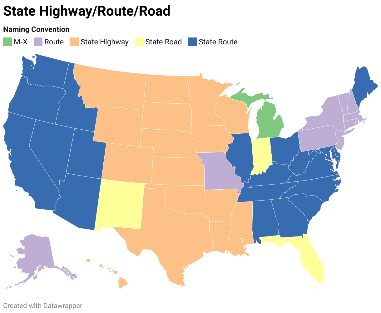
State Departments of Transportation use different terminology for their designated road systems, with some states using "state highway," others "state road," and still others "state route." These distinctions, though seemingly minor, often reflect historical and legislative traditions within each state. The choice of a particular term can be tied to the legal language used when the road network was first established or expanded. For example, a state might have initially defined its network as a "system of highways" for commerce and travel, while another may have focused on creating a "system of roads" for local and inter-city connections. The term "state route" is often a more modern designation that emphasizes a specific numbered path for navigation rather than the physical characteristics or purpose of the road itself. While the exact reasoning for each state's choice is complex and rooted in its unique history, the map on the right provides a visual guide to which term is used where.
Explore Tennessee Route 385 from Millington to Arlington with this 17-mile drive through suburban Shelby County. Follow this high-speed corridor past Millington’s Navy base, rolling hills, and the eastern edge of Memphis.

Drive Tennessee State Route 385 west from Arlington to Millington in this 17-mile scenic corridor connecting I-40 and US-51. Explore rolling hills, rural interchanges, and the gateway to Naval Support Activity Mid-South.

Take a scenic 28-mile drive along Oklahoma Highway 66 from Oklahoma City to El Reno, exploring Route 66 landmarks, Lake Overholser Bridge, and the historic towns of Yukon and El Reno.

Take a short but scenic drive along Tennessee Route 120 from Bumpus Mills to the Kentucky state line. This 3-mile rural route winds through wooded hills and farmland, offering a peaceful glimpse into Stewart County’s countryside.

Explore a swift and scenic drive along Tennessee State Route 22 from Huntingdon to McKenzie. This 11-mile journey connects two Carroll County towns with a four-lane bypass and rural charm, ending at the US-79 junction toward Paris.

Drive America’s Highways for 8.5 miles south along Ohio Route 49 from Clayton to Dayton. Explore suburban hubs, historic road alignments, and urban gateways on this essential connector through Montgomery County.

Explore the Bella Vista Bypass before its transformation into Interstate 49. Take a scenic 11-mile drive along the old AR-549 in Northwest Arkansas, capturing a snapshot of the region’s growth.

Experience the Bella Vista Bypass before it became part of Interstate 49. Drive north along the old AR-549 route in Northwest Arkansas and see the road as it was in its original two-lane form.

Take a drive on the Sam Rayburn Tollway from McKinney to Frisco, Texas. Follow this 11.6-mile suburban toll route past major interchanges, commercial centers, and growing neighborhoods in Collin County.

Take a short but engaging drive along Texas Highway 302 westbound through Greenville, Texas. Explore local intersections, small-town character, and connections to U.S. Highways 69 and 380 in this scenic four-mile journey.

Drive 53 miles along the Talimena National Scenic Byway from Mena, Arkansas, to U.S. 271 in Oklahoma, experiencing stunning Ouachita Mountain views, Queen Wilhelmina State Park, and endless scenic vistas.

Take a drive through the heart of North Texas on the Dallas North Tollway, from Interstate 35E in Dallas to TX-121 in Frisco, passing urban skylines, corporate hubs, and vibrant suburbs in this 20-mile stretch.