Cruise 25 miles along Arkansas Highway 10 from Perry to Ola and discover a relaxing drive through farmland, forest, and the heart of rural Arkansas. Enjoy the scenery, small towns, and easy access to Petit Jean State Park along the way.

State highways form the backbone of regional travel across the United States, offering essential connections between cities, rural communities, and major national routes. Managed by individual state departments of transportation, these highways vary widely in scale—from narrow rural byways to multi-lane expressways rivaling interstates in traffic and speed. While numbering systems and signage conventions differ from state to state, each network plays a critical role in local mobility and economic development.
Unlike the federally designated Interstate and U.S. Highway systems, state highways are developed and maintained at the state level, giving them a unique character and flexibility. Some follow historic paths and scenic corridors, while others serve as modern commuter routes or urban spurs. Many are vital links to state parks, natural attractions, and lesser-known destinations that don't fall within the national systems.
On this site, we highlight a growing collection of notable state highways, organized by region and state. Whether you're tracing a scenic loop through the mountains, navigating a fast-moving corridor through a metro area, or exploring forgotten rural routes, our guides offer detailed overviews, and video journeys to help you plan your next adventure.

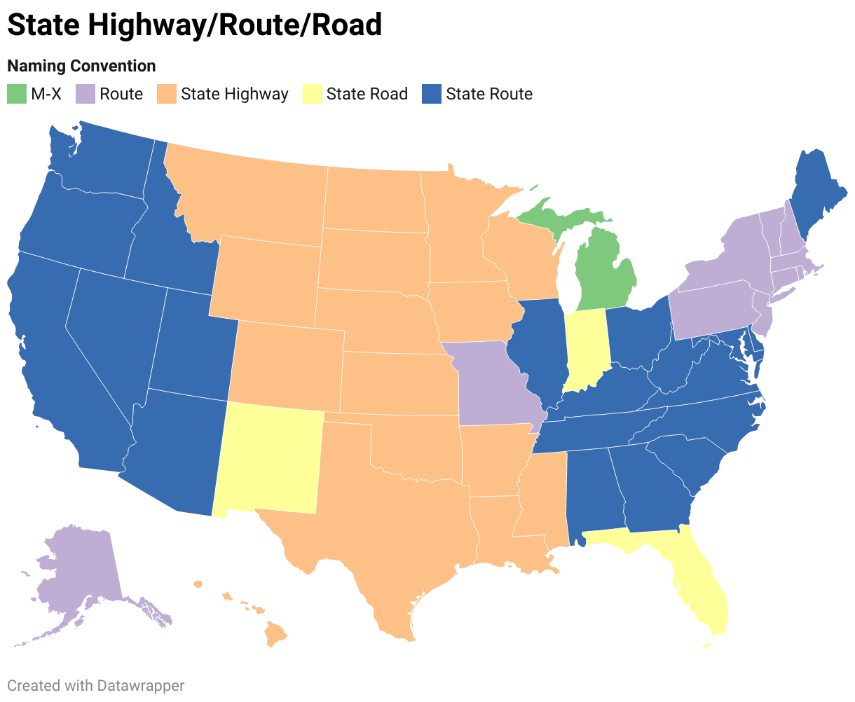
State Departments of Transportation use different terminology for their designated road systems, with some states using "state highway," others "state road," and still others "state route." These distinctions, though seemingly minor, often reflect historical and legislative traditions within each state. The choice of a particular term can be tied to the legal language used when the road network was first established or expanded. For example, a state might have initially defined its network as a "system of highways" for commerce and travel, while another may have focused on creating a "system of roads" for local and inter-city connections. The term "state route" is often a more modern designation that emphasizes a specific numbered path for navigation rather than the physical characteristics or purpose of the road itself. While the exact reasoning for each state's choice is complex and rooted in its unique history, the map on the right provides a visual guide to which term is used where.

Cruise 25 miles along Arkansas Highway 10 from Perry to Ola and discover a relaxing drive through farmland, forest, and the heart of rural Arkansas. Enjoy the scenery, small towns, and easy access to Petit Jean State Park along the way.

Take a peaceful drive along Arkansas Highway 171 through Lake Catherine State Park near Hot Springs. This short but scenic route passes the park’s beach, cabins, campgrounds, and day-use areas, showcasing the forested beauty and lakeside charm of one of Arkansas’s inviting state parks.

Cruise Arkansas Highway 171 from Diamondhead to Lake Catherine State Park for a quick escape into pine forests, lake views, and one of the state’s coziest outdoor retreats. Perfect for a day trip or weekend getaway.

Cruise 3 miles east along Arkansas Highway 290 from Red Oak to Diamondhead, weaving through forested backroads to reach the lakeside community near Hot Springs. A short, scenic connector with easy access to Lake Catherine State Park.

Drive 3.5 miles along Arkansas Highway 128 (Carpenter Dam Road) from Hot Springs to Red Oak, crossing the Ouachita River and skirting Lake Hamilton for a quick scenic escape south of the city.

Take a quick drive down Arkansas Highway 88 into the peaceful town of Lonsdale. This short connector showcases rural Arkansas charm, transitioning from wooded countryside to quiet residential streets in under a mile.

Experience over 100 curves through the Ozark Mountains on Arkansas Highway 341 — Push Mountain Road — from Big Flat to Norfork. A must-drive for riders and drivers seeking epic scenery and thrilling twists.

Cruise 17 scenic miles through the Ozark National Forest along Arkansas Highway 14, from Allison near Mountain View to Big Flat. Highlights include the Sylamore Scenic Byway, Blanchard Springs Caverns, and classic Ozark backroad charm.

Cruise Arkansas Highway 9 for 34 miles from Clinton to Mountain View. This scenic backroad cuts through Ozark forests and farmland, passing Shirley and Rushing before ending in the folk music hub of Mountain View.

Cruise 10 miles west on Arkansas Highway 84 from Social Hill to De Roche for a peaceful rural drive through central Arkansas pine country, with easy access to DeGray Lake Resort State Park near Caddo Valley.

Cruise 41 miles of scenic Ozark backroads along Arkansas Highway 16 from Witts Springs to Clinton. Pass through forests, quiet communities, and rolling hill country for a relaxing taste of rural Arkansas.

Cruise 11 miles north along Maine State Route 11 from Eagle Lake to Fort Kent and enjoy a tranquil slice of Aroostook County—dense forests, riverside views, and a gateway to the end of US-1 at the Canadian border.